Unit 1
Reading maps
Use a map's scale, key and grid to find places and measure real distances from a small drawing.
Read
A town on a piece of paper
Imran's class is going to a science park. The teacher hands out a map and says, "Find the toilets, the café and the exit, and tell me how far it is to walk from the gate to the dinosaur garden."
Imran stares at the paper. The whole park, with its lakes and paths and buildings, fits on one sheet. How can that be? And how can anyone tell how far from a drawing?
The answer is that a map is a scaled-down model of a real place. Everything on it is drawn smaller than in real life, but by the same amount everywhere. That is why you can use it to measure. A good map comes with three helpers: a scale, a key and a grid.
The scale: shrinking by the same amount
The scale tells you how much smaller the map is than the real place. A common way to write it is "1 cm = 200 m". It means: every 1 centimetre on the paper stands for 200 metres on the ground.
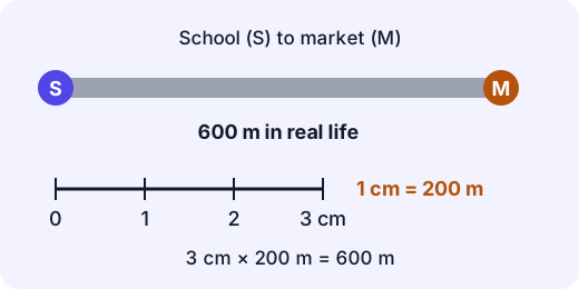
Many maps also have a scale bar, a little ruler printed on the map. You can lay the edge of a strip of paper along the road you want to measure, mark its ends, and then hold the strip against the scale bar.
Example. On a map the scale is 1 cm = 200 m. The road from the school to the market measures 3 cm on the map. How far is it in real life?
- One centimetre stands for 200 m.
- There are 3 centimetres, so multiply: .
- The road is 600 m long. That is roughly a ten-minute walk.
You can also go the other way. If you want to know how long to draw a 1,000 m (1 km) road at the same scale, divide: , so draw it 5 cm long.
Try it: A map says 1 cm = 5 km. Two towns are 4 cm apart. How far apart are they in real life? (Check: km.)
A common mix-up. The scale belongs to one map. "3 cm" does not always mean 600 m. On a map with the scale 1 cm = 1 km, the same 3 cm means 3 km! Always read the scale first. Also, the scale only works for a straight line. For a bendy road, lay a piece of string along the bends, then straighten the string and measure it.
The key: what the symbols mean
A map can't draw every tree and every house, so it uses simple symbols. The key (also called the legend) is the list that tells you what each symbol stands for. On the map of Ashok Nagar further down, a purple S is a school and a blue oval is a pond. Always read the key before you read the map. Another map may use different symbols!
The grid: a name for every square
How would you tell a friend exactly where the temple is on a big map? Mapmakers draw a grid of squares. Letters run along the top and numbers run down the side. Each square gets a name made from its letter and its number: its grid reference.
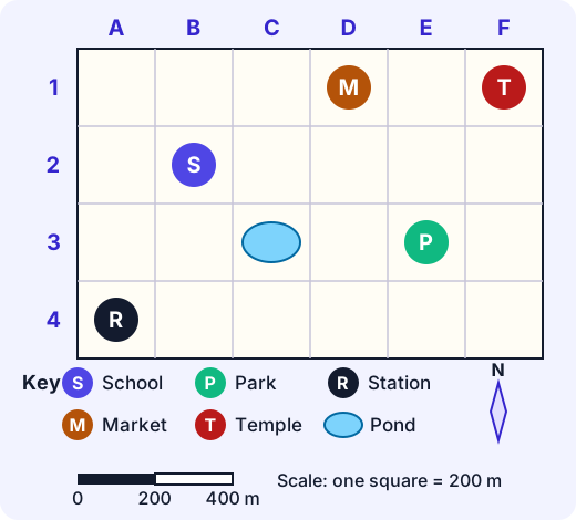
The rule is across first, then down: find the letter along the top, find the number down the side, and look at where the column and the row meet. (A way to remember: you walk along the corridor before you go up the stairs. Grid references work the same way: the letter comes first.)
Example. Use the map above.
- Where is the market? Go along the top to D, then down to row 1. The market is in D1.
- What is at B2? Along the top to B, down to 2. That square holds the school.
- How far is the pond (C3) from the park (E3)? They are in the same row, with one square between them. They are 2 squares apart. The scale bar says one square is 200 m, so the walk is m.
Putting it together
When you need to find something, use all three helpers in turn:
Helper The question it answers Key What is this symbol? Grid Which square is it in? Scale How far is it from here? Maps also show direction with a compass rose, which you met in earlier work. Together, these tools turn a sheet of paper into something you can navigate by, even in a place you have never seen.
Lab
Riverbend map hunt
Find places on the map of Riverbend using its key and grid, then work out real distances from the scale. Eight short questions.
Your goals
- Find places from their grid references, and give the grid reference of a place.
- Use the key to say what is in a square.
- Use the scale (one square = 100 m) to find three real distances.
The interactive lab opens once you register. Register to do this.
Activity
Draw a map of your street
Draw a scaled map with a key, a grid and a scale of the room you are in, or of your home and the closest street. About 40 minutes.
You'll need
- Squared paper (or plain paper and a ruler)
- Pencil, eraser and coloured pencils
- A tape measure, a metre ruler or a long piece of string with knots every 10 cm
Steps
- Choose a space you can walk across safely, such as one room or your garden. Do not cross a road to measure anything.
- Measure the length and width of the space in steps or in metres. Write the numbers down.
- Choose a scale so the drawing fits your paper. For example, if the room is 5 m long and your paper is 25 squares across, you could say one square = 20 cm. Write the scale on the map and draw a scale bar.
- Measure two or three big things (a bed, a table, a door) and draw them as rectangles on the map using your scale.
- Make a key with a symbol and a name for each thing on the map. Add a compass rose that shows north.
- Add a grid, with letters along the top and numbers down the side. Write the grid reference of each thing.
- Swap maps with someone. They must find three things using only your key and grid, then work out the real distance between two of them with your scale.
Safety
- Stay in your home, garden or school ground. Measure with an adult nearby if you leave the building.
- Do not stand on chairs or tables to measure.
Keeping a log of the activity is for registered learners. Register to do this.
Quick check
Map skills check
Eight questions about the map of Ashok Nagar and about scale. Use the key, the grid and the scale bar.
1.What is the grid reference of the station?
- A4
- D1
- C3
- 4A
Choose one
2.What is in square D1?
- The school
- The market
- The temple
- The pond
Choose one
3.How many metres is it, in a straight line along the row, from the pond (C3) to the park (E3)?
Answer with a number
4.A map has the scale 1 cm = 50 m. A path measures 6 cm on the map. How many metres long is the path?
Answer with a number
5.A map has the scale 1 cm = 2 km. Two villages are 5 cm apart on the map. How many kilometres apart are they?
Answer with a number
6.Why does a map have a key?
- It tells you what the symbols on the map mean
- It tells you how far apart places are
- It gives every square a name
- It shows which way is north
Choose one
7.Put these steps in order to find a place from its grid reference, such as D1.
- Look where the column and the row meet
- Find the number down the side
- Find the letter along the top
Put these in order
8.Match each part of a map to its job.
- Scale
- Key
- Grid
Match each to: Explains the symbols · Gives each square a reference · Turns map lengths into real distances
Answering and checking are for registered learners. Register to do this.
Quick check
New puzzles
Use scale and grid references in situations you have not seen before.
1.A map has the scale 1 cm = 3 km. Two towns are 7 cm apart on the map. How many kilometres apart are they in a straight line?
Answer with a number
2.A cycling trip is 8 km long. The map scale is 1 cm = 2 km. How many centimetres long is the route on the map, if it were a straight line?
Answer with a number
3.A treasure hunt starts in square B2. Go 3 squares to the right (east), then 2 squares down (south). Which square do you end in? Write the grid reference.
Answer with a word or phrase
4.A map of a hall shows its 8 m width as 4 cm. What is the scale of that map?
- 1 cm = 2 m
- 1 cm = 4 m
- 1 cm = 8 m
- 1 cm = 12 m
Choose one
5.Two maps show the same lake. On map A the lake is 2 cm long. On map B it is 6 cm long. Which statement must be true?
- Map B has a larger drawing of the lake, so 1 cm on map B stands for a shorter real distance
- The lake is three times longer in real life on map B
- Both maps must have the same scale
- Map A is wrong
Choose one
Answering and checking are for registered learners. Register to do this.
Your turn
Teach a friend to read a map
A younger cousin has a map of a zoo. The scale is 1 cm = 50 m. The map has a grid with letters along the top and numbers down the side. She asks: "How do I find the lion house, and how do I know how far I'd have to walk?"
Write an answer for her (6 to 10 sentences). It should:
- Say what each of the three map helpers (key, grid, scale) is for.
- Show how to use the grid to find a place, with an example grid reference such as C4.
- Show how to work out a real distance, using a made-up measurement. For example, the lion house is 8 cm from the gate on the map. Show the sum.
- Warn her about one mistake people make with scales.
How it's judged
- Meaning of key, grid and scale
- Worked examples
- Understanding of scale
Writing and submitting your answer is for registered learners. Register to do this.
Like what you see?
Register for free to answer the quick checks, do the activities and save your work. Your work is saved on your device and syncs to your account.