Unit 1
Locating places on Earth
Why every flat map of a round Earth bends the truth, and how to read scale, projection and distortion so you can trust a map for the job it was made for.
Read
Why no flat map is true
Peel an orange and try to press the peel flat on a table. It tears, or it crumples, or you have to stretch it. No matter how patient you are, a piece of a sphere will not lie flat without being cut or distorted. The Earth is (very nearly) a sphere, and every map in your atlas, on your phone and on your classroom wall is a flat picture of it. So every one of them is a compromise.
That does not make maps bad. It makes them tools, each built for a job. This unit teaches you to ask the two questions that make any map readable: how big is the world on this page (scale)? and how was the round Earth flattened (projection)?
The globe: the honest model
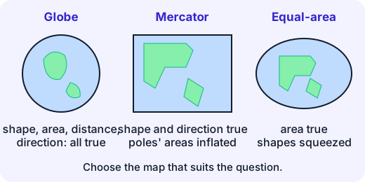
A globe is a small copy of the Earth. Because it is also round, it keeps shapes, areas, distances and directions in true proportion all at once. Its weakness is practical: you can only see one half at a time, it is bulky, and it cannot show the street where you live in any useful detail. Maps trade away some truth to gain convenience.
You already know the grid of latitude (parallels, measured north and south of the equator) and longitude (meridians, measured east and west of the prime meridian). Both maps and globes use this grid to name any place by two numbers. Chennai, for example, lies at about N, E.
Scale: how much is the world shrunk?
Scale is the ratio between a distance on the map and the same distance on the ground. It is written in three ways:
Kind Example Meaning Statement "1 cm represents 10 km" read it directly Ratio (representative fraction) 1 unit on the map = 1,000,000 of the same unit on the ground Scale bar a ruler drawn on the map still correct if the map is enlarged or shrunk The ratio and the statement "1 cm = 10 km" say the same thing, because .
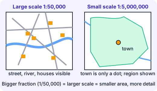
Misconception. "A large-scale map covers a large area." It is the opposite. The fraction is bigger than , so is the larger scale. It shows a small area in great detail: you can see individual lanes. A world map at is a small-scale map: huge area, little detail.
Example (distance from the map). On a map with scale , two towns are 6 cm apart.
- cm on the ground.
- Convert: km.
Example (map from the distance). You want to draw a 45 km road on a sheet where it must be 9 cm long. The scale is (45 km is 4,500,000 cm), which simplifies to .
A handy shortcut: take the ratio, cut off five zeros, and you get kilometres per centimetre. For that is km per cm; check: km.
Try it: A straight line from Delhi to Mumbai is about 1,150 km. How long would it be on a map at ? (Here 1 cm = 100 km.) Does it fit on your page?
Projection: flattening the sphere
A map projection is a rule for moving each point of the globe's surface to a flat sheet. Mathematicians have proved that no rule can keep everything. A flat map can preserve some of these, never all:
- shape (a small island looks like its true outline),
- area (a country is the right size compared to others),
- distance (measured lengths are in proportion),
- direction (a compass bearing is a straight line).
So every projection distorts, and the cartographer chooses what to sacrifice.
Mercator: right for sailors, wrong for sizes
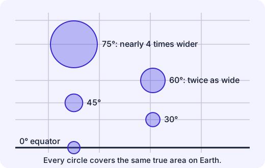
In 1569 the Flemish map-maker Gerardus Mercator drew a world map on which any straight line is a path of constant compass bearing. For a navigator that was a gift: draw a line from port to port, read the angle, steer it. To achieve this, the map stretches east–west distances more and more as you move away from the equator, and stretches north–south by the same factor so that small shapes stay the right shape.
The stretch factor at latitude is . At it is : lengths are doubled. Areas grow by the square of that, so a patch at looks times too big.
Example. Greenland has an area of about 2.2 million km², while Africa covers about 30 million km², so Africa is roughly 14 times larger. On a Mercator map, Greenland (at – N) looks almost as big as Africa (straddling the equator). The map is not lying about angles; it is telling the truth about a different thing than size.
Misconception. "The map is wrong, so the Mercator map is a mistake." Every projection is "wrong" about something. Mercator is excellent for the purpose it was designed for, and misleading when used to compare the sizes of countries. The mistake is using a tool for a job it was not made for.
Other families of projection
- Equal-area projections (for example Gall–Peters or Mollweide) keep areas correct, so you can compare the size of India and Greenland fairly, but countries look squashed or stretched out of shape.
- Compromise projections (Robinson, Winkel Tripel) spread the error around: nothing is perfect, nothing is terrible. Many atlases and the National Geographic Society have used them for world maps.
- Conic projections work well for countries in the middle latitudes, such as many maps of India.
Why do long flights look curved on a flat map? The shortest path between two places on a sphere is an arc of a great circle (the biggest circle you can draw on the globe). Stretch the globe flat and that arc usually becomes a curve. A flight from Mumbai to London that appears to bend north over Iran and Turkey is flying as straight as it can.
Choosing a map
You want to… Use Because Plot a sea route by compass Mercator straight line = constant bearing Compare sizes of countries an equal-area map or a globe areas are true Find your way round a town large-scale plan () detail, distances nearly true Show a whole world picture to a class a globe, or a compromise map least distortion overall At very large scales, such as a town plan, the area covered is so small that the curve of the Earth barely matters, and distortion is too small to notice. Distortion is a problem at small scales, when you try to show continents on one page.
Summary
- A globe is the true model; flat maps always distort one of shape, area, distance or direction.
- Scale tells you how much the world is shrunk; large scale = small area, much detail.
- Mercator preserves local shape and direction, and exaggerates area near the poles.
- A map is useful when you know what it simplifies, and match it to your question.
Lab
Stretch and scale explorer
Slide a circle of fixed true size up the Mercator map to see how the map stretches it, then use scale to turn map lengths into real distances.
Your goals
- Find the latitude where Mercator doubles lengths, and read the stretch at 75 degrees.
- Solve three scale problems with the map ratio.
The interactive lab opens once you register. Register to do this.
Quick check
Scale and projection check
Eight questions on reading scale and understanding why flat maps distort.
1.You want a map that shows the lanes and buildings of your own village. Which scale suits best?
- 1 : 25,000
- 1 : 2,500,000
- 1 : 100,000,000
Choose one
2.A map has the scale 1 : 1,000,000. Two towns are 7.5 cm apart on it. How far apart are they on the ground, in km?
Answer with a number
3.The scale bar says 1 cm = 250 km. Chennai and Kolkata are 4.4 cm apart on the map. About how many km is that?
Answer with a number
4.You are drawing a map at the scale 1 : 20,000,000. A real distance is 600 km. How many cm long is it on your map?
Answer with a number
5.Why can a flat map never show the whole Earth without distortion?
- Map-makers have not yet found the best method, and computers will solve it.
- A curved surface cannot be flattened without stretching, squeezing or tearing it.
- The Earth is not really round, so any map of it is guesswork.
Choose one
6.Which statements about the Mercator projection are true? Choose all that apply.
- Greenland looks far larger compared with Africa than it really is.
- A straight line on it is a path of constant compass bearing, which helped sailors.
- It shows the areas of all countries correctly.
- It shows both poles as small points.
Choose all that apply
7.Match each map to the job it does best.
- Globe
- Mercator map
- Equal-area map
Match each to: Fairly comparing the sizes of countries · Plotting a ship's course with a compass · Keeps shape, area, distance and direction roughly true all at once
8.Put these maps in order from the smallest scale (least detail, most area) to the largest scale (most detail, least area).
- Town map, 1 : 50,000
- Plan of a school, 1 : 500
- Map of India, 1 : 15,000,000
- World atlas page, 1 : 100,000,000
Put these in order
Answering and checking are for registered learners. Register to do this.
Quick check
Map puzzles
Use what you know about scale and projection in situations the reading did not show.
1.A school field is 120 m long. You draw it 24 cm long on a page. Its scale is 1 : n. What is n?
Answer with a number
2.A trekking map says 1 cm = 500 m. Write its scale as 1 : n. What is n?
Answer with a number
3.A newspaper wants one world map so readers can fairly compare how much land different countries cover. What should it choose?
- An equal-area map, because areas are drawn in true proportion.
- A Mercator map, because it is the most famous.
- Any map, since sizes never change between projections.
Choose one
4.On a flat world map, an airline's route from Mumbai to London is drawn as a curve, not a straight line. What is the best explanation?
- The pilot is avoiding mountains the whole way.
- The shortest path on a sphere is a great-circle arc, which usually looks curved once the globe is flattened.
- The map-maker drew it wrongly.
Choose one
Answering and checking are for registered learners. Register to do this.
Your turn
Why every map distorts
Answer in your own words (about 150 to 250 words in all).
- A friend says, "My atlas shows Greenland as big as Africa. Either it is wrong or you are wrong." Explain what is going on, using the words projection and distortion. Say what the map is good for and what it is bad for.
- A map has the scale . Two cities are 3.5 cm apart on it. Show your working to find the real distance in km. Then say whether this is a large-scale or a small-scale map compared with a town plan, and why.
- Choose one job (for example, navigating a ship, teaching a class about the sizes of continents, or finding a shop in town). Name the map type and scale you would choose and give a reason.
How it's judged
- Explaining distortion
- Using scale
- Matching map to purpose
Writing and submitting your answer is for registered learners. Register to do this.
Like what you see?
Register for free to answer the quick checks, do the activities and save your work. Your work is saved on your device and syncs to your account.