Unit 3
Landforms and water
Meet mountains, plains, plateaus, deserts, rivers and coasts, and find out how each one shapes where people live.
Read
Why is the village here?
Two villages. The first sits high on a mountain slope in Himachal Pradesh. Its houses have thick stone walls and sloping roofs, and its fields are built in narrow steps. The second sits on the flat plain beside the river Ganga. Its fields stretch out as far as you can see, and boats rest on the bank.
Why are these villages so different? Because the land is different. The shape of the ground, called a landform, decides what people can grow, how they travel, what they build and where they live. In this unit you will meet six big landforms and water bodies and see how people use each one.
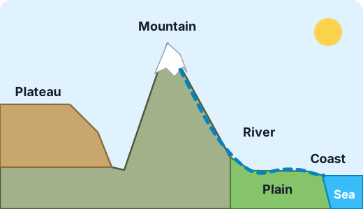
Six landforms and water bodies
Name What it is How people use it Mountain Very high land with steep slopes and a peak. It is cooler the higher you go. Terraced farms, orchards, herding, forests, hydro-power dams, tourism. Few big cities. Plain Wide, low, flat land. Often covered with deep soil that rivers have laid down. Farming (wheat, rice, sugarcane), roads and railways, big cities. Plateau High land with a flat top and steep sides, like a table. Farming (such as cotton), grazing, and mining, because many plateaus hold coal, iron and other minerals. Desert Land with very little rain (usually less than about 250 mm a year). Herding, small farms at oases and with irrigation, salt and mineral work, solar power. River Water flowing in a channel from high land towards a lake or the sea. Drinking water, fishing, irrigation, boats, power, towns on the banks. Coast Where land meets the sea. Fishing, ports and trade, salt-making, beaches and tourism. Example from India. The Himalaya are a mountain range, and Mount Everest on the Nepal–Tibet border is the highest mountain on Earth at about 8,849 m. South of them lies the great Ganga plain, one of the most crowded farmland regions in the world, because the rivers keep it fertile. In the middle and south, the Deccan plateau is high, flat-topped and partly covered with dark soil that suits cotton. In the north-west, the Thar desert gets little rain; people there herd camels, goats and sheep. India's long coast (more than 7,000 km), including the Konkan coast in the west, holds ports such as Mumbai and Chennai and thousands of fishing villages.
A river's journey
A river starts as small streams high in the hills or mountains, where rain falls or snow melts. The place where it starts is called its source. As it flows downhill it picks up smaller rivers called tributaries, grows wider and slower, and crosses plains, dropping mud and sand. Where it meets the sea, its end is called the mouth. Some rivers spread out into fan-shaped land built of mud, a delta. The Sundarbans in India and Bangladesh are in the delta of the Ganga and the Brahmaputra.
Try it: Draw a river on paper from a mountain to the sea. Label the source, a tributary, a town on the plain and the mouth. Then put in a delta if you like.
Why landforms decide where people live
Look at where most people live, and a pattern shows up. Plains and river valleys have flat land, water and good soil, so many people live there. Deserts and high mountains are harder to farm, so fewer people live there. Coasts attract people who fish and trade.
Example. Egypt is mostly desert. But about nine in ten Egyptians live in a thin green strip beside the river Nile, and in its delta. The river brings water and soil to a land that gets almost no rain. So the river, not the desert, decides where people settle.
Example. In the Andes mountains of South America, farmers have built terraces for hundreds of years. A terrace is a flat step cut into a slope. It stops soil and water from washing straight downhill, so crops can grow where the ground is steep.
Mix-ups to avoid
- A mountain is not the same as a plateau. A mountain has a peak. A plateau has a wide flat top.
- Deserts are not always hot or sandy. Many deserts have rocks or gravel instead of sand. Some are cold: Ladakh and Antarctica are deserts because they get very little rain or snow. The word "desert" is about dryness, not heat.
- Landforms do not decide everything. People change land too, with canals, terraces, roads and dams. But the landform sets what is easy and what is hard.
Water bodies
A lake is a body of water surrounded by land. A sea or ocean is a very large body of salt water. A river carries fresh water towards them. Together with landforms, water bodies make up the physical features of a place, and people use all of them.
Lab
Where would people settle?
Six cards describe ways of life. Match each one to the landform where it fits best, and read why.
Your goals
- Match each way of life (fishing and ports, terraces, wide farmland, herding, river towns, mining) to its landform.
- Read the reason that follows each match.
The interactive lab opens once you register. Register to do this.
Activity
Build a landform tray
Make a model of a mountain, a plateau, a plain, a river and a coast in a tray, then test where the water goes. About 45 minutes.
You'll need
- A large baking tray or a cardboard box lid lined with a plastic bag
- Modelling clay or damp sand and soil, or salt dough
- A jug of water and a spoon
- Small paper flags and toothpicks, a pencil, paper
Steps
- Build a tall pointed mountain at one end of the tray. Press a flat-topped block of clay beside it for the plateau. Leave a low, flat area for the plain. Slope the clay down to the low end of the tray for the coast.
- Make a sea by leaving the lowest end of the tray bare, or lay a bit of blue paper there.
- Slowly pour a little water on top of the mountain. Watch where it runs. Draw the path it takes on paper. That is your river.
- Label the mountain, plateau, plain, river and coast with paper flags.
- Place small flags where you think a village, a port, a farm and a mine would go. Write on each flag why you put it there.
- Pour more water and see whether any of your places gets flooded. Move a flag if you need to.
- Tell someone at home how your model shows that landforms affect where people live.
Safety
- Put the tray on a table with a towel under it, or work outside.
- Wash your hands after touching clay, sand or soil. Do not eat any modelling materials.
- Ask an adult before using the kitchen jug and baking tray.
Keeping a log of the activity is for registered learners. Register to do this.
Quick check
Landforms check
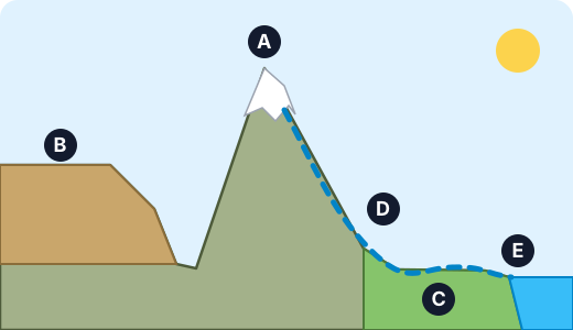
Eight questions. The first four use the picture, where letters A to E mark five features.
1.What landform is marked A?
- Mountain
- Plateau
- Plain
- Desert
Choose one
2.What landform is marked B?
- Mountain
- Plateau
- Plain
- Coast
Choose one
3.What landform is marked C?
- Plateau
- Mountain
- Plain
- Delta
Choose one
4.What do we call the place marked E?
- A coast
- A source
- A plateau
- A desert
Choose one
5.Match each place in India to its landform.
- Thar
- Deccan
- Himalaya
- Ganga
- Konkan
Match each to: Desert · River · Mountain range · Coast · Plateau
6.Which statements about deserts are true? Pick all that are.
- Deserts get very little rain
- Deserts are always hot
- Deserts are always covered in sand
- Some deserts are cold
Choose all that apply
7.Put the parts of a river's journey in order, from start to finish.
- It crosses the plain, leaving fertile mud
- It reaches the sea at its mouth
- It starts as small streams from melting snow in the mountains
- Tributaries join it and it grows wider
Put these in order
8.What is the name of the fan-shaped land of mud that some rivers build where they meet the sea?
Answer with a word or phrase
Answering and checking are for registered learners. Register to do this.
Quick check
New puzzles
Use what you know about landforms in places the reading did not visit.
1.In the Sahara desert, a town has grown up around a natural spring. Why do people settle there?
- The spring gives water in a land with almost no rain
- Sand is the best soil for farming
- Deserts are always cold, and the spring warms the town
- The spring is the coast of the sea
Choose one
2.Farmers in the Himalaya cut flat steps into the mountainside. What problem do the steps solve?
- On a steep slope, soil and water would run straight downhill; steps hold them so crops can grow
- The steps keep the sea out
- The steps stop desert sand from blowing in
- The steps make the mountain taller
Choose one
3.Which of these places would you expect to have the most people living in each square kilometre?
- The Ganga plain
- The middle of the Thar desert
- The highest peaks of the Himalaya
- Antarctica
Choose one
4.A geologist reports a high, flat-topped region where coal and iron ore lie under the ground. Which landform does that describe best?
- A plateau
- A delta
- A coast
- A mountain peak
Choose one
5.A country wants to build a big port to ship goods to other continents by sea. Which place is the best choice?
- On the coast, where deep water is close to land
- On the top of a plateau
- In the middle of a desert
- Near a mountain peak
Choose one
Answering and checking are for registered learners. Register to do this.
Your turn
How does land shape life?
Choose one landform or water body from this unit (mountain, plain, plateau, desert, river or coast). Pick a real example in India or somewhere else in the world, such as the Himalaya, the Ganga plain, the Deccan plateau, the Thar desert, the Nile or the Konkan coast.
Write 6 to 10 sentences that:
- Describe what the landform looks like and how it is different from one of the other landforms.
- Give two ways that people use it (for example, for food, work, travel or homes).
- Explain how the landform makes it easy to live in some ways and hard in others.
- Say what you think would change for people if this landform were not there.
How it's judged
- Describing the landform
- Ways people use it
- Cause and effect
Writing and submitting your answer is for registered learners. Register to do this.
Like what you see?
Register for free to answer the quick checks, do the activities and save your work. Your work is saved on your device and syncs to your account.