Unit 3
Oceans and continents
Follow the great ocean currents, see how they warm and cool coasts, and find out why oceans have been the world's highways far longer than its barriers.
Read
Rivers inside the sea
In January 1992 a ship crossing the North Pacific lost a crate in a storm. Inside were thousands of plastic bath toys: yellow ducks, blue turtles, red beavers. Over the following months and years they washed up on beaches in Alaska, and others were found thousands of kilometres from where they were lost. Scientists who tracked the toys learned something no map showed: the sea is not still. It is full of slow, wide rivers, called ocean currents, that carry water, heat, fish, ships and, sometimes, rubber ducks, around the planet.
Oceans and continents
About 71% of Earth's surface is water. Most of it lies in one connected "world ocean", which we divide for convenience into five oceans.
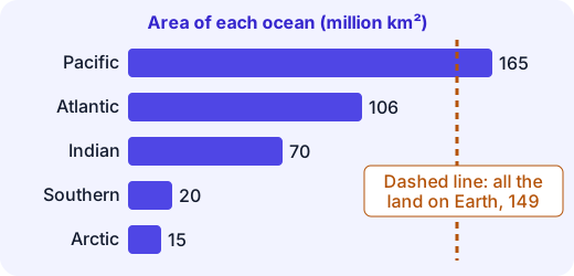
The Pacific alone is larger than all the land on Earth put together. The seven continents (Asia, Africa, North America, South America, Antarctica, Europe, Australia/Oceania) are large landmasses; some geographers count Europe and Asia as one continent, Eurasia. Because the ocean is one connected body, a drop of water can in principle travel from the Arctic to the Indian Ocean. This is why we say oceans connect more than they divide.
What drives ocean currents
Surface currents have three main drivers:
- Wind. Steady winds such as the trade winds push the top few hundred metres of water along.
- Earth's rotation. The spinning Earth bends moving water to the right in the northern hemisphere and to the left in the southern (the Coriolis effect).
- Continents. Land blocks the water, turning it aside like the wall of a bathtub.
Together these make huge circles of moving water called gyres: clockwise in the northern hemisphere, anticlockwise in the southern.
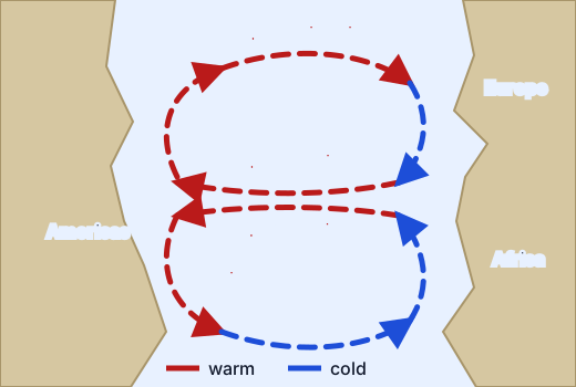
Look at the north Atlantic loop. Water heated in the tropics flows west with the trade winds (the North Equatorial Current), turns north along North America as the warm Gulf Stream, crosses the ocean as the North Atlantic Drift, and swings south as the cool Canary Current, completing the circle. A rule of thumb: currents moving away from the equator along a coast are warm; currents moving towards it are cold.
There is also a deep, slow circulation. Cold, salty water is dense and sinks near the poles, and creeps along the sea floor, taking hundreds of years to complete the great "conveyor belt" journey. We will focus on surface currents, because ships and coastal climates feel those.
Currents and climate
Water holds heat well, so a warm or cold current changes the air above it.
- A warm current warms and moistens a coast. The Gulf Stream and North Atlantic Drift, together with the westerly winds, help make north-west Europe far milder than places at the same latitude on other coasts. The port of Murmansk, Russia, north of the Arctic Circle, stays ice-free all year because warm water reaches it.
- A cold current cools and dries a coast. Cold water makes less water vapour, so the air above it brings fog but little rain. The Humboldt (Peru) Current helps make the Atacama coast one of the driest places on Earth, and the Benguela Current does the same for the Namib in south-west Africa.
Worked example. Compare Lima, Peru, and Salvador, Brazil. Both are coastal cities about – south of the equator.
Lima Salvador Latitude about S about S Mean annual temperature about about Yearly rain about 10 mm about 1,900 mm Coast current cold (Humboldt, flowing north) warm (Brazil Current, flowing south) Same distance from the equator, very different climates. The difference comes from the water offshore. The cold current cools the air and suppresses rain, while the warm current feeds the coast with heat and moisture.
Misconception. "Latitude alone decides how hot a place is." Latitude, altitude, distance from the sea, winds and ocean currents all play a part.
Where warm and cold currents meet, mixing brings up nutrients, so the meeting zones, such as the Grand Banks off Newfoundland, are among the richest fishing grounds.
Currents and trade routes
The sea has always been the cheapest way to move heavy goods; about 90% of world trade by volume still goes by ship. Sailors learned to use the currents and winds rather than fight them.
- The Atlantic loop. Columbus in 1492 sailed south to the Canary Islands, then west on the trade winds and the North Equatorial Current. To return, he went north and then east, using the westerlies and the Gulf Stream and North Atlantic Drift. Sailing the loop was faster than going straight back.
- The monsoon trade of the Indian Ocean. In the Indian Ocean, the winds, and the surface currents they drive, reverse with the seasons. Ships came from Arabia and East Africa to India's west coast on the south-west monsoon of summer, and sailed home on the north-east winds of winter. Harappan traders sailing to Mesopotamia more than 4,000 years ago, and later Roman, Arab and Chola merchants, used this clockwork. Lothal, a Harappan port in Gujarat, had a great brick dock.
- Canals as shortcuts. The Suez Canal (1869) joins the Mediterranean and the Red Sea, so ships from Europe to India no longer sail round Africa. The Panama Canal (1914) saves ships thousands of kilometres between the Atlantic and the Pacific.
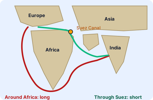
For India, with a coastline of over 7,500 km, ports such as Mumbai, Chennai and Kolkata carry most trade by volume. The sea is the road to the world.
Misconception. "Oceans separate countries." Look at history instead: for thousands of years, travel by sea was often easier than travel across mountains and deserts. Polynesian navigators settled islands scattered across thousands of kilometres of open Pacific by reading waves and stars. Spices, ideas, religions and diseases crossed seas long before they crossed ranges.
Summary
- The world ocean is one connected body, divided into five oceans around seven continents.
- Surface currents are driven by wind, Earth's rotation and the shape of continents, forming gyres.
- Warm currents warm and moisten coasts; cold currents cool and dry them.
- Sailors used currents and monsoon winds; canals cut routes. Oceans connect more than they divide.
Lab
Sail the Atlantic loop
Plan a ship's round trip from Lisbon to the Caribbean and home, choosing each leg to use the ocean currents, then read three coasts to decide whether a warm or a cold current lies offshore.
Your goals
- Plan a round trip of 70 sailing days or fewer by riding the currents both ways.
- Answer three questions about how currents change the climate of a coast.
The interactive lab opens once you register. Register to do this.
Quick check
Oceans and currents check
Eight questions on ocean currents, their effects on climate and trade, and the world ocean.
1.Which set of causes best explains why surface currents form huge circular gyres?
- Wind, the spin of the Earth, and the shapes of the continents
- The Moon's pull only
- Rivers pushing the sea around
Choose one
2.In which direction does the north Atlantic gyre turn?
- Clockwise
- Anticlockwise
- It does not turn; it flows straight.
Choose one
3.Match each current to what it does.
- Gulf Stream
- Humboldt (Peru) Current
- Benguela Current
Match each to: Cold current that cools Lima and helps make the Atacama coast dry · Warm current from the tropics that helps keep north-west Europe mild · Cold current flowing north along south-west Africa, linked to the foggy Namib coast
4.San Francisco, at about 38 °N on the Pacific coast of North America, has cool, foggy summers. Which is the most likely cause?
- A cold current (the California Current) flows south along that coast.
- A warm current flows north along that coast.
- Currents have no effect on coastal weather.
Choose one
5.About 71% of Earth's surface is covered by water. About what percentage is land?
Answer with a number
6.Which effects does a cold current usually have on the coast it passes? Choose all that apply.
- It cools the air over the coast.
- It makes rain less likely and fog more likely.
- It brings heavy rainforest rain.
- It makes winters much warmer.
Choose all that apply
7.Why did the Suez Canal shorten voyages between Europe and India?
- It joins the Mediterranean and Red Sea, so ships no longer sail all the way round Africa.
- It makes the Gulf Stream flow faster.
- It joins the Atlantic and Pacific oceans.
Choose one
8.Put the stages of a round trip on the north Atlantic loop in order, starting from Europe.
- Reach the Caribbean
- Return north-east on the Gulf Stream and North Atlantic Drift
- Cross west on the trade winds and the North Equatorial Current
- Sail south to the Canary Islands
Put these in order
Answering and checking are for registered learners. Register to do this.
Quick check
Ocean puzzles
Use what you know about currents and trade in settings the reading did not show.
1.A sailing ship leaves Rio de Janeiro for Cape Town. In the south Atlantic gyre, which route does the current help most?
- South along the Brazil Current, then east across the ocean
- North along the coast of Brazil, then east along the equator
- Straight west, away from Africa
Choose one
2.A merchant in Gujarat wants to sail to East Africa in the old days. When should the ship leave for the best wind from behind?
- In winter, on the north-east monsoon
- In summer, on the south-west monsoon
- Season makes no difference to the wind.
Choose one
3.Fishing fleets gather where a warm and a cold current meet. What is the best reason?
- Mixing there brings up nutrients that feed fish.
- The water is always calm there.
- Ships are not allowed to sail in other places.
Choose one
4.Suppose a desert coast with a cold current offshore were instead washed by a warm current. Which changes would you expect? Choose all that apply.
- More rain on the coast
- Warmer coastal air
- More fog and an even drier climate
Choose all that apply
Answering and checking are for registered learners. Register to do this.
Your turn
How the sea links places
Write about 200 words.
- Explain, in your own words, what drives the surface currents of an ocean and why they form gyres. Use the north Atlantic as your example.
- Describe one effect of an ocean current on the climate of a coast. Name the current, say whether it is warm or cold, and say what happens to the temperature or rain.
- Describe one way ocean currents or ocean winds helped trade or travel in the past (for example the monsoon sailing season, or Columbus's loop across the Atlantic).
- A friend says, "Oceans divide the world into separate pieces." Reply to your friend in two or three sentences using what you have learned.
How it's judged
- Explaining currents
- Climate effect
- Trade and connection
Writing and submitting your answer is for registered learners. Register to do this.
Like what you see?
Register for free to answer the quick checks, do the activities and save your work. Your work is saved on your device and syncs to your account.